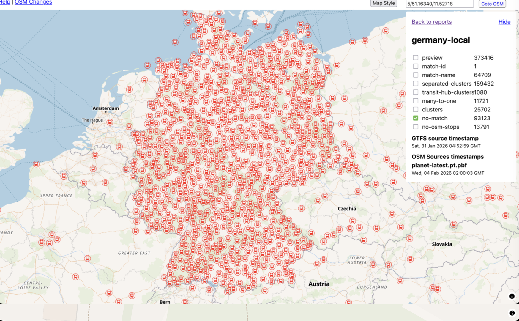
We're working on live public transport schedules as the first step to public transport routing. Here is the helper web app that shows currently supported GTFS feeds in different countries and cities and helps to match bus/tram/train stops from OpenStreetMap.org with stops from GTFS: https://gtfs-osm-matcher.organicmaps.app/
If you are interested in public transport schedules in your city, please let us know about feeds for your place/country, and help by adding/editing stops in OpenStreetMap.org
Post


@organicmaps _Please_ use Transitous for this data. Sure you don't have to let them calculate the route, but at least use their data rather than fetching and parsing GTFS feeds yourself! These kind of projects have to work together rather than doing the same work again.
@bart thanks, we’re already looking at it. The main difference is that we also want to improve OpenStreetMap.org map data quality by providing community with a tool to add missing stops, or correct existing ones.
@organicmaps That's good to hear and makes complete sense 👍


@organicmaps We‘d like to invite you to present your plans at the #OpenTransportMeetup and exchange wit the open transport community. Meet the folks from @transitous and other public transport projects there to coordinate efforts. @CoMaps, you are invited, too. https://github.com/transportkollektiv/meetup/wiki#welcome-to-the-german-open-transport-meetup-wiki

@organicmaps
Of cool, will @CoMaps integrate that too?


@organicmaps GTFS for Asturias, region in northern Spain. https://nap.transportes.gob.es/Files/Detail/977


@organicmaps Here's the static GTFS for Vigo, Spain. The only problem is the transit information is loaded as calendar_dates items and only for a few days, meaning you have to either reimport it or manually modify it to make it "long-term" somehow. https://datos.vigo.org/data/transporte/gtfs_vigo.zip
There's also a feed for Xunta de Galicia (regional transit authority), but the data quality is not great. You need to sign up (for free) to the spanish NAP to download feeds
https://nap.transportes.gob.es/Files/Detail/1386

@organicmaps All collective transport in norway is available through Entur https://developer.entur.org/

@organicmaps Please also add the UK


@organicmaps You should be able to get most of french available feeds here → https://transport.data.gouv.fr/datasets?format=GTFS&type=public-transit

@organicmaps This is the real time GTFS feed for Torino,Italy:
http://aperto.comune.torino.it/dataset/feed-gtfs-real-time-trasporti-gtt

@organicmaps
Here's a GTFS data site for Okinawa, Japan. Seems to be both bus and ferry routes.
https://www.ottop.org/gtfs-opendata
And here's an API endpoint:
Here's collected bus route data for many parts of Japan (Okinawa sourced from above I believe):
@jannem is it the official, original source feed? Or just an aggregate?
@organicmaps
It looks to me the top links is from an NPO that collects and promotes open data for Okinawa.
The bottom link is an aggregator that collect such data from all over the country.
Public transport is all run by private companies here, so there's probably no single "official" collection point for an area anywhere.

@organicmaps flixtrain feeds can be found here: https://www.transit.land/feeds/f-u-flixbus


@organicmaps good luck. Our public transport system is working on that too


@organicmaps It seems that for the Netherlands, you need to also use a different reference field into account as well: ref:IFOPT
See for example https://gtfs-osm-matcher.organicmaps.app/#/match-report/netherlands/selection/no-match/3479640 — the stop is there, with:
ref:IFOPT="NL:Q:41321660"
This matches the Gtfs stop Code.
Similarly with https://gtfs-osm-matcher.organicmaps.app/#/match-report/netherlands/selection/no-match/3479647, https://gtfs-osm-matcher.organicmaps.app/#/match-report/netherlands/selection/no-match/3828602, and quite a few others.


@organicmaps You can add Sofia Bulgaria to the list:
https://www.sofiatraffic.bg/en/info-center/gtfs-danni

@organicmaps Just dumping this here (unable to help in the near term) but Dutch PT open data is published through


@organicmaps GTFS schedule is available for Porto, PT city buses here: https://opendata.porto.digital/dataset/horarios-paragens-e-rotas-em-formato-gtfs-stcp/resource/89a6854f-2ea3-4ba0-8d2f-6558a9df2a98
Can't find real-time, though I know it exists because there are apps that use it.

@organicmaps I haven't checked about redundancies, but these are available feed from Catalonia:
* Intercity buses in Catalonia: https://territori.gencat.cat/ca/serveis/visors-cartografia/bases-cartografiques/infraestructures-mobilitat/autobusos-interurbans/index.html#googtrans(ca|en)
* FGC (Catalan Government Railways): https://dadesobertes.fgc.cat/explore/?q=gtfs&flg=es&sort=modified
* Rodalies de Catalunya (Commuter Railways of Catalonia): https://data.renfe.com/dataset/horarios-cercanias
* AMB buses (Metropolitan Area of Barcelona) : https://www.amb.cat/en/web/area-metropolitana/dades-obertes/cataleg/detall/-/dataset/gtfs-real-time-bus-service/6332347/11692
* TMB buses (Barcelona Metropolitan Transport): https://www.tmb.cat/en/tmb-app-and-other-apps/tools-for-developers
@organicmaps https://www.atm.it/IT/VIAGGIACONNOI/Pagine/default.aspx on this site you can find all the info about public transportation in Milan.
I hope I can be helpful by uploading some datas about stops in the following days 

@organicmaps What would a perfectly tagged Stop look like so many projects can make use of the information?
@klopf 1. Stop is on the map; 2. It has gtfs id tag(s) to match the same stop in one or more gtfs feeds.


@organicmaps Is there a manual available? I'm happy to help, and I frequently edit OpenStreetMap, but I'm unfamiliar with how GTFS is supposed to work.
@cimm working on it. Any feedback is welcome. Check the web app, it highlights non-matched PT stops.
@organicmaps According to the OSM's wiki it seems I need to add gtfs:stop_id, gtfs:stop_name and uic_ref tags to the station node. The values can be found in the GTFS feeds (which I found via TransitLand). Easy enough!
@cimm right! Note that there could be more than one feed in some cases for different transport agencies.


@organicmaps German Transport Feed Specification


@cheeaun Do you know if Singapore has GTFS data that can be used?


@sohkamyung @cheeaun @organicmaps I'm not aware of any GTFS publicly available. It needs to be converted from an API.
@smsm1 @sohkamyung @cheeaun maybe someone can contact local government for the feed access? Another alternative is to write an api converter into gtfs format, we can also support that.


#germany should see a doctor about a cream for that, it looks _nasty_
That's great work though @organicmaps - love it!


@organicmaps why not using something like Transitous?
@yotamn we’re checking different options. To compete with e.g. Google, live PT routing should scale well for millions of users. And of course the privacy aspect.

@organicmaps @yotamn transitious is open source, you are redoing all the work to use and find gtfs feeds. Both of you could safe massive time by cooperating
@shadowwwind @yotamn we have different goals. To scale PT for a billion of users, routes should be calculated in Organic Maps app, not on a server.
@organicmaps @yotamn you can probably still use their parser, knowledge, routing engine and collection of feed urls

@organicmaps here you have the GTFS-RT feed for Renfe's suburban railway lines https://data.renfe.com/dataset?res_format=GTFS-RT